Jews and Navigation
Fact Paper 9
© Samuel Kurinsky, all rights reserved
Pre-Columbian Navigation
Intercontinental trade was pioneered by Persian Jews who pioneered the "Silk Route" to the heart of China in the fifth century BCE.1 Augustus, the first Roman emperor, is said to have commissioned "the first travel guide" from Isidore of Charax (a town on the Euphrates River estuary on the Persian gulf). Centuries later, while the Europeans were still deep in the Dark Ages, Persian Rhadanite scholar/travelers pioneered land and sea trade routes to the Far East.2
"These merchants speak Arabic, Persian, Roman, Frankish, Spanish, and Slavonic," wrote Ibn Khurdadhih in the ninth century CE, "They travel from East to West and from West to East by land as well as by sea."3
Judaic savants were largely responsible for the invention and development of the instruments and astronomical tables which thereafter facilitated world-girdling sea voyages.
Jews had long learned from the Talmud that the world was a globe. In the fourth century, the Jerusalem Talmud (Aboda Zara, 42c) unequivocally asserted that the world was globular in form. The Zohar (Leviticus 1.3) was even more specific, declaring that the earth rotates on its axis like a ball.. The great Maimonides and other medieval Judaic scientists subscribed to that concept.
Th thirteenth century fabulist Isaac ben Sahulla made the antipodean theory familiar widely among the Jews in his work, Meshal haKadmoni. The theory held that peoples feet pointed to the center of a spherical earth. Thus, the concept of a globular world was inherent in Judaic tradition from the most ancient times. Roger Bacon (1213-92), an English friar, quoted Hebrew sources to show that Asia could be reached by sailing west from Europe. The church proscribed the reading of Bacons books and Bacon was imprisoned.
Rationalists of the early Renaissance continued to be restricted by the church for propounding "Judaic" wisdom. Deviation from an earth-centered universe was treated as heresy. Long after the churchs posits became indefensible, Judaic astronomical precepts were ignored.
In the thirteenth century, the King of Castile, Alfonso the Wise, instructed Judah ben Moses Cohen, and Isaak be Sid, a Chasan (cantor) in a Toledo synagogue, to update astronomical tables compiled by Judaic astronomers in the eleventh century, and to translate them into Spanish. They became known as the "Alfonsine Tables," and were used by Galileo and Kepler four centuries later to develop their theories.
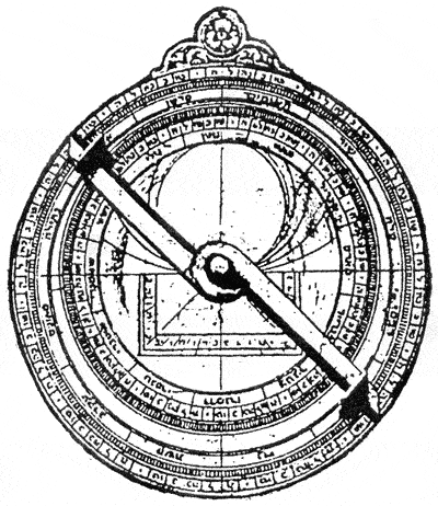
Astronomical tables were likewise compiled by Joseph ben Wakkar at Toledo in 1396, and in Aragon by various Judaic savants. Other significant calculations were made by Emanuel ben Jacob, known as "Bonfils de Tarascon." The tables were used in conjunction with an astrolabe, an instrument introduced into the Arab-speaking world by a remarkable Jewish genius, Mashala of Mosul, "the phoenix of his age." The use of the astrolabe, an instrument for taking the altitude of heavenly bodies, in conjunction with the astronomical tables, helped determine a ships position at sea.
The quadrant was another device as important as the astrolabe for navigation on the high seas. That instrument measured the right ascension (angle from the horizon) of the sun and stars. An advanced model, designed by Rabbi Joseph bn Makhir, became known as the Quadrant Judaicus. Rabbi Makhir compiled the calendar used by Dante, and was quoted as a authority long after his passing by Copernicus and Kepler.
Another Rabbi, Levi ben Gershom, in southern France, devoted 136 chapters to astronomy in his major work, The Wars of the Lord. Included in that work was an improved quadrant that became known as Jacobs Staff. For three centuries thereafter, Renaissance explorers depended on Gershoms instrument for determining latitude and the local hour.4
Nautical instruments and astronomical tables were adjuncts to maps in guiding seafarers to their destination. The most notable cartographers could be found among the Jews. Geographic intelligence was a boon of Judaic dispersion into the Diaspora. Information gleaned by Judaic travelers, deposited with compatriots along their itinerary, was transmitted to other passing Judaic travelers. Geographic intelligence was likewise passed along through correspondence delivered by these travelers from region to region.
Majorka, strategically placed midway between Africa and Europe, became a beehive of Judaic map-making. The Majorcans were unrivaled seafarers, knowledgeable about coastal configuration. The Jews among them became cartographers par excellence.5
Abraham Crescas headed a renowned map-making family. Their works illustrate countless books on travel and geography, and are the valued possession of museums. Abraham was appointed "Master of Maps and Compasses" by Juan of Aragon. As compensation, he obtained permission to build a mikvah for his co-religionists. Abraham and his son, Jehuda, produced what is probably the most famous of ancient maps, a mapamundi depicting the Atlantic coasts and the "mysterious ocean" beyond.
Jehuda continued as a cartographer after his fathers death, but was forced to convert in the wave of baptisms of 1391. He assumed the name Jayme Ribes. Eventually he was invited to Portugal by Prince Henry "The Navigator," where he became the first director of the famous nautical observatory as "Maestre Jacome de Majorka."
Haym ibn Risch, another outstanding Majorcan cartographer, was likewise forced to convert in 1391. He adopted the name Juan de Vallsecha. He was probably the father of Gabriel Vallsecha, author of yet another famous mapamundi, one later used by Amerigo Vespucci.
Still another significant cartographer of Majorka was Mecia de Vildestes. An outstanding map by Vildestes dated 1413 is proudly featured at the Bibliothèque Nationale of Paris.
The Church Concedes: the World Goes Around
Colonialist ambitions finally superseded church astronomical strictures; Greed for gold took precedence over dogma.
The Italians point to the Florentine, Paolo Toscanelli, as the inspiration for Columbus. Toscanelli, following the Judaic precept that the earth was globular, calculated its circumference to be about half its actual length. The acceptance by Columbus of this calculation led him to believe that a westward voyage to the Indies was feasible.6
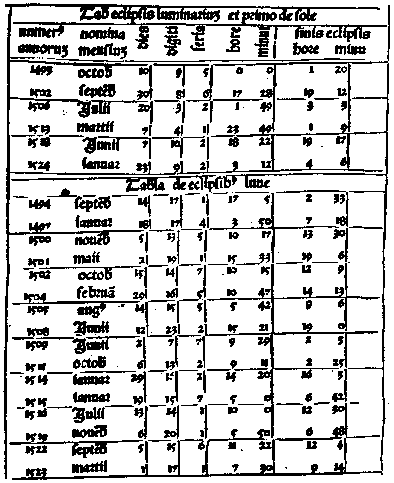
Columbus never met Toscanelli. He conferred with Abraham Zacuto (1452-1515), a professor at the University of Salamanca, about the feasibility of a westward voyage to the Near East. Zacuto was the most reputable astronomer of the day. Zacutos astronomical tables, together with his perfected astrolabe, made the voyages of navigators like Columbus possible. Zacuto plotted the route to be taken, and instructed Columbus on it.
Zacuto got no thanks for his pivotal contribution to Spains greatness. In 1492, when the Columbus expedition was assured, the expulsion of the Jews from Spain was under way. Abraham Zacuto found himself facing the Inquisition. He refused baptism, fled to Portugal, and was immediately honored with an appointment as Astronomer-Royal, the most prestigious scientific post in the western world. In Portugal, Zacutos activity reached its zenith. He devised a newer and improved astrolabe which became the standard in subsequent voyages by all the colonialist adventurers.
When the inquisitorial plague blighted Portugal in 1497, Zacuto refused to convert; he managed to escape to North Africa, where he wrote the well-known chronicle, Sepher Judaism.
The series of astronomical tables Zacuto compiled at Salamanca were translated into Latin and Spanish by his pupil, Joseph Vecinho, and published by the Judaic printer, "Magistor Ortas" at Leiria in 1496. Despite Zacutos Judaic identity, his tables were carried in the voyages of the fleets of Columbus, Vasca de Gama, Joao da Nova, and Albuquerque. Vasca da Gamas ships were also outfitted with Zacutos astrolabe.
Just as Columbus had conferred with Zacuto before Zacuto was forced to flee Spain, so Vasca da Gama conferred publicly with Zacuto before sailing from Lisbon on July 8th, 1497; he took affectionate leave of Zacuto in the presence of his entire crew. Zacuto was forced to flee Portugal soon thereafter.
Much is made about Da Gamas "discovery," in disregard of the substantive Judaic presence in India, dating from before Roman times. Jews were respected in many of the princedoms along Indias coast; many rose to exalted positions. On arriving at Anchediva, not far from Goa in India, Da Gama was greeted by a tall Jew with a flowing white beard who had risen to the rank of admiral to the viceroy of Goa.
Cecil Roth notes that Da Gamas treatment of the old man was particularly ungrateful. Da Gama had him seized and tortured until he consented to be baptized and to pilot the Portuguese flotilla in Indian waters. Roth adds that da Gamas own grandson, Gaspar da Gama, was a "New Christian." Gaspar was one of the first Portuguese to set foot on the soil of Brazil.
"Another victim of the forced conversions," adds Roth, "was Pedro Nuñes, who, a mere child at the time, subsequently became professor of mathematics at Coimbra, and chief cosmographer to the crown of Portugal. He, too, remained closely attached to Judaism in secret; so much that at the beginning of the seventeenth century... his grandsons were tried by the Inquisition for judaising."
In 1537 Nuñes Treatise on the Spheres was published; it laid the foundation for Mercators work, "and thus for the whole system of modern cartography." Nuñes also developed a revolutionary instrument for graduating mathematical instruments. It was called the Nonius, and was subsequently used be Vernier in a somewhat improved version, and is still essential for exacting engineering. The last king of Portugal, unsuspecting of Nuñes Judaic origin, had no hesitation in calling this Marrano scientist "the most distinguished Portuguese nautical astronomer."
Notes
Much information and un-noted quotations are from Cecil Roth, "The Great Voyages of Discovery," ch.IV, The Jewish Contribution to Civilization, London 1956. Refer to this outstanding book for a comprehensive digest of the subject.
- Hebrew History Federation Ltd, Fact Paper 3, The Silk Route; A Judaic Odyssey.
- Samuel Kurinsky, The Glassmakers; An Odyssey of the Jews, ch. 8 "The Linen, Glass, Silk and SpiceRoute," and Ch 9, "The Sassanian Experience," New York 1991.
- Ibn Khurdadhbih, The Book of Routes and the Kingdoms.
- For further information about the quadrant, astrolabe, and astronomical tables see HHF Newsletters 52 and 54. For early Judaic maritime trade see HHF Newsletter 49.
- A. Lionel Isaacs, The Jews of Majorka, London, 1936.
- Moritz Kayserling, Christopher Columbus, Carmi House Press, N. Hollywood, 1989.